Białka/en
m (→Łysa Polana - Jurgów Szałasy) |
m |
||
| Linia 1: | Linia 1: | ||
{{Languages|Białka}} | {{Languages|Białka}} | ||
| − | {{ | + | {{River |
| − | | | + | | name=Białka |
| − | | | + | | country=Poland |
| − | | | + | | region=Tatry |
| map_id=bialka | | map_id=bialka | ||
| − | | | + | | difficulty=1-3 (4) |
| − | | | + | | mouth=Dunajec/en |
}} | }} | ||
Wersja z 08:24, 23 paź 2012
| Białka | |
| Country | Poland |
| Region | Tatry |
| Class | 1-3 (4) |
| Map | Białka |
| Tributaries |
?? |
| Mouth | Dunajec/en |
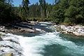
Białka is a right bank tributary of the Dunajec. Białka has source in Tatry Wysokie - it is a connection of Rybi Potok and Biała Woda.

Every year, at the end of the June and the beginning of July, AKTK "Bystrze" organizes a training camp called Białka Szkoleniowa.
Spis treści |
River sections
Łysa Polana - Jurgów Szałasy
- Put-in: on the left bank of the river, below the old PL-SK border, or few hundred meters below,
- Take out on the right bank of the river, close to the ski lift above the Jurgów village (there is a dirty road to the river),
- Difficulty: WW III (IV),
- Length: ca. 8 km,
- Time: 2 h (small group with HW 1.5 h).
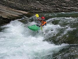
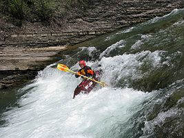
The most interesting and most difficult section of the river.A few hundred meters at the beginning has a high gradient,the river has an alpine character, there are huge obstacles in the channel. The hardest cataract is class III-IV.
Afterwards river becomes easier, similar to the next (lower) section, but with a bit bigger gradient. There are some big stoppers.
Warning: due to its location in Tatra National Park, paddling this section is prohibited by law!
Warning: there are often trees in the river!
Jurgów Szałasy - Czarna Góra bridge
- Put-in: on the right bank of the river, close to the ski lift above the Jurgów village (there is a dirty road to the river), at the mouth of Jaworowy Potok,
- Take out on the left bank, on the road bridge in Czarna Góra village (second bridge while paddling the river, road 49),
- Difficulty: WW II,
- Length: ca. 5 km,
- Time: 1 h.
This is the most popular section of Białka, class II (by HW few places class III). Put in at the Jaworowy Potok mouth (so-called bąbel), close to Podokólne clearing, by the road 49.
Watch out for several big stoppers in the second part of the section!
Czarna Góra bridge - Trybsz bridge
- Put-in: on the left bank, on the road bridge in Czarna Góra village (second bridge while paddling the river, road 49),
- Take out on the right bank, before the road bridge in Trybsz,
- Difficulty: WW I-II,
- Length: ca. 7-8 km,
- Time: ?.
This section is significantly easier than the upper ones. Close to the Białka Tatrzańska village, there is a big stopper, which may be dangerous with high water (so-called Odwój Białczański).
Odwój Białczański
Odwój Białczański


Trybsz bridge - Nowa Biała bridge
- Put-in: on the right bank, before the road bridge in Trybsz,
- Take out: on the road bridge between Nowa Biała and Krempachy
- Difficulty: WW I,
- Length: ?,
- Time: ?.
This section is rarely paddled as a separate section (rather with the upper one). There is one more interesting place, called Przełom Białki.

Water level
Łysa Polana
There is a water gauge close to the PL-SK border in Łysa Poland (visible form the bridge on the river, on the left bank). It is most proper for the first section of the river.


The gauge is to check at website pogodynka.pl.
Trybsz
The another gauge is in the Trybsz village. It should be more accurate for the lower sections (beginning from Jurgów Szałasy). However, currently we do not know its readings ;)
The level 230 cm (52 m3/s) seems to be a typical flood water (HHW)


Photos
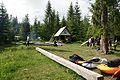
Podokólne Clearing (close to Jurgów Szałasy)
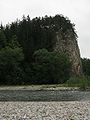
Przełom Białki
Bąbel after the flood in 2008r.


GPS Coordinates
Map
See also
External links
| To jest tylko zalążek artykułu. Jeśli potrafisz, rozbuduj go. |