Białka/en
m (→Map) |
|||
| Linia 7: | Linia 7: | ||
| map_id=bialka | | map_id=bialka | ||
| trudność=WW I-III (IV) | | trudność=WW I-III (IV) | ||
| + | | ujscie=Dunajec | ||
}} | }} | ||
| Linia 19: | Linia 20: | ||
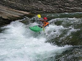
=== Łysa Polana - Jurgów Szałasy === | === Łysa Polana - Jurgów Szałasy === | ||
| − | Most interesting and most difficult section of river. Few hundret meters in the beginning has a high gradient , river has an alpine character, there are huge | + | * '''Start''': on the left river bank, below the old PL-SK border, or few hundert meters below, |
| + | * '''Finish''' on the right river bank, close to the ski lift above the Jurgów village (there is a dirty road to the river), | ||
| + | * '''Difficulty''': [[WWW III]] (IV), | ||
| + | * '''Length''': ca. 8 km, | ||
| + | * '''Time''': 2 h (small group with HW 1.5 h). | ||
| + | |||
| + | Most interesting and most difficult section of river. Few hundret meters in the beginning has a high gradient, river has an alpine character, there are huge | ||
obstacles in the channel. The hardest [[cataract]] is class [[Skala WW#WW III|III-IV]]. | obstacles in the channel. The hardest [[cataract]] is class [[Skala WW#WW III|III-IV]]. | ||
Afterwards river becomes easier, similair to the following section, but with a bit bigger gradient. There are some big [[stopper]]s. | Afterwards river becomes easier, similair to the following section, but with a bit bigger gradient. There are some big [[stopper]]s. | ||
| − | ''Warning''' due to its location in Tatra National Park, paddling this section is prohibited by law! | + | '''Warning''': due to its location in Tatra National Park, paddling this section is prohibited by law! |
| + | |||
| + | '''Warning''': there are ofter trees in the river! | ||
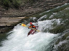
=== Jurgów Szałasy - Czarna Góra bridge === | === Jurgów Szałasy - Czarna Góra bridge === | ||
| − | This is the most popular section of [[Białka]], [[ | + | * '''Start''': on the right river bank, close to the ski lift above the Jurgów village (there is a dirty road to the river), at the mouth of [[Jaworowy Potok]], |
| − | (so-called ''bąbel''), close to Podokólne clearing | + | * '''Finish''' on the left bank, on the road bridge in Czarna Góra village (second bridge while paddling the river, road {{droga|49|plred}), |
| + | * '''Difficulty''': [[WW II]], | ||
| + | * '''Length''': ca. 5 km, | ||
| + | * '''Time''': 1 h. | ||
| + | This is the most popular section of [[Białka]], [[WW II|class II]] (by HW few places class III). Put in at the [[Jaworowy Potok]] mouth | ||
| + | (so-called ''bąbel''), close to Podokólne clearing, by the road {{droga|49|plred}}. | ||
| + | |||
| − | + | === Czarna Góra bridge - Trybsz bridge === | |
| − | + | * '''Start''': on the left bank, on the road bridge in Czarna Góra village (second bridge while paddling the river, road {{droga|49|plred}), | |
| + | * '''Finish''' on the right bank, before the road bridge in Trybsz, | ||
| + | * '''Difficulty''': [[WW I]]-II, | ||
| + | * '''Length''': ca. 7-8 km, | ||
| + | * '''Time''': ?. | ||
| − | [[ | + | This section is significantly easier than the upper ones. Close to the Białka Tatrzańska village, there is a big [[stopper]], which may be dangerous with high water (so-called ''Odwój Białczański''). |
| − | == | + | <gallery widths="320" heights="200"> |
| − | + | Image:Odwoj_Bialczanski_Poldziobek.jpg|Odwój Białczański | |
| + | Image:Odwoj_Bialczanski_Kozica.jpg|Odwój Białczański | ||
| + | </gallery> | ||
| − | + | === Trybsz bridge - Nowa Biała bridge === | |
| + | * '''Start''': on the right bank, before the road bridge in Trybsz, | ||
| + | * '''Finish''': on the road bridge between Nowa Biała and Krempachy | ||
| + | * '''Difficulty''': [[WW I]], | ||
| + | * '''Length''': ?, | ||
| + | * '''Time''': ?. | ||
| − | + | This section is rarely paddled as a separate section (rather with the upper one). There is one more interesting place | |
| − | |||
Odcinek bywa bardzo rzadko pływany jako osobny odcinek. Może być połączony z odcinkiem wyższym. Na odcinku znajduje się ''Przełom Białki''. | Odcinek bywa bardzo rzadko pływany jako osobny odcinek. Może być połączony z odcinkiem wyższym. Na odcinku znajduje się ''Przełom Białki''. | ||
Trudność [[Skala WW#WW I|WW I]] | Trudność [[Skala WW#WW I|WW I]] | ||
Wersja z 11:19, 7 maj 2010
Białka is a right bank tributary of the Dunajec. Białka has source in Tatry Wysokie - it is a connection of Rybi Potek and Biała Woda.

Every year, at the end of the June and the beginning of July, AKTK "Bystrze" organizes a training camp called Białka Szkoleniowa.
Spis treści |
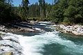
River sections
Łysa Polana - Jurgów Szałasy
- Start: on the left river bank, below the old PL-SK border, or few hundert meters below,
- Finish on the right river bank, close to the ski lift above the Jurgów village (there is a dirty road to the river),
- Difficulty: WWW III (IV),
- Length: ca. 8 km,
- Time: 2 h (small group with HW 1.5 h).
Most interesting and most difficult section of river. Few hundret meters in the beginning has a high gradient, river has an alpine character, there are huge obstacles in the channel. The hardest cataract is class III-IV.
Afterwards river becomes easier, similair to the following section, but with a bit bigger gradient. There are some big stoppers.
Warning: due to its location in Tatra National Park, paddling this section is prohibited by law!
Warning: there are ofter trees in the river!
Jurgów Szałasy - Czarna Góra bridge
- Start: on the right river bank, close to the ski lift above the Jurgów village (there is a dirty road to the river), at the mouth of Jaworowy Potok,
- Finish on the left bank, on the road bridge in Czarna Góra village (second bridge while paddling the river, road {{droga|49|plred}),
- Difficulty: WW II,
- Length: ca. 5 km,
- Time: 1 h.
This is the most popular section of Białka, class II (by HW few places class III). Put in at the Jaworowy Potok mouth (so-called bąbel), close to Podokólne clearing, by the road 49.
Czarna Góra bridge - Trybsz bridge
- Start: on the left bank, on the road bridge in Czarna Góra village (second bridge while paddling the river, road {{droga|49|plred}),
- Finish on the right bank, before the road bridge in Trybsz,
- Difficulty: WW I-II,
- Length: ca. 7-8 km,
- Time: ?.
This section is significantly easier than the upper ones. Close to the Białka Tatrzańska village, there is a big stopper, which may be dangerous with high water (so-called Odwój Białczański).
Odwój Białczański
Odwój Białczański


Trybsz bridge - Nowa Biała bridge
- Start: on the right bank, before the road bridge in Trybsz,
- Finish: on the road bridge between Nowa Biała and Krempachy
- Difficulty: WW I,
- Length: ?,
- Time: ?.
This section is rarely paddled as a separate section (rather with the upper one). There is one more interesting place
Odcinek bywa bardzo rzadko pływany jako osobny odcinek. Może być połączony z odcinkiem wyższym. Na odcinku znajduje się Przełom Białki. Trudność WW I

Water level
Pegel na Białce znajduje się przy granicy w Łysej Polanie, poniżej mostu drogowego na Słowacji, na lewym brzegu. Jest on najbardziej odpowiedni dla odcinka pierwszego (Łysa Polana - Jurgów Szałasy), gdyż na początku odcinka kolejnego Białka jest zasilana wodą z Jaworowego Potoku.
Stan pegla jest podawany na stronie IMGW (bieżące zagrożenia) po osiągnięciu przez Białkę stanu alarmowego - powyżej 200 cm.
Highest levels
- 23 lipca 2008, po południu, na peglu było 300 cm. Następnego dnia okazało się, że w moście w Czarnej Górze pojawiła się dziura przez całą szerokość mostu, a most Krępachy-Nowa Biała został zniszczony.
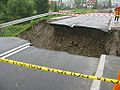
Most w Czarnej Górze po powodzi
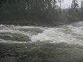
Ujście Jaworowego Potoku do Białki przy 225 cm na peglu
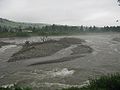
Całkowinie zmieniona Białka powyżej mostu w Czarnej Górze po powodzi
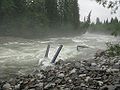
Zniszczone rury do pobierania wody na Torze


Photos
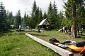
Polana Podokólne
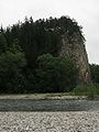
Przełom Białki
Bąbel po powodzi w 2008r.


GPS Coordinates
Map
See also
External links
| To jest tylko zalążek artykułu. Jeśli potrafisz, rozbuduj go. |