Paravani/en
m (→River sections) |
|||
| (Nie pokazano 5 wersji utworzonych przez 2 użytkowników) | |||
| Linia 13: | Linia 13: | ||
}} | }} | ||
| − | [[Paravani]] is one of the most interesting rivers in Georgia close to the border with Turkey, | + | [[Paravani]] is the hardest classic in the Lesser Caucasus and one of the most interesting rivers in Georgia close to the border with Turkey and Armenia. Paravani river drains huge swamps, the following Paravani Lake stores the water after rains. So you find even enough water in the summer months. Especially in low water below Akhalkalaki the river is very polluted. Also a hydropower plant is in construction at the moment (June 2012). It is not clear which sections will be affected by that. |
| Linia 19: | Linia 19: | ||
{{RiverSection | {{RiverSection | ||
|name=Upper | |name=Upper | ||
| − | |putin=on the right bank of the river, below Akhalkalaki | + | |putin=on the right bank of the river, below Akhalkalaki, at a bridge made of train wagon. |
| − | |takeout=on the right bank of the river, below the most difficult rapid | + | |takeout=on the right bank of the river, below the most difficult rapid (very close to the road but easy to miss from the car) |
|length= | |length= | ||
|time=3 h | |time=3 h | ||
|gradient= | |gradient= | ||
| − | |difficulty=4-4+ | + | |difficulty=4-4+ (5) |
|update=2012 | |update=2012 | ||
}} | }} | ||
<gallery widths="320" heights="240" perrow="2"> | <gallery widths="320" heights="240" perrow="2"> | ||
| − | Image:Paravani_start_Scheuer.jpg| | + | Image:Paravani_start_Scheuer.jpg|This bridge serves as remarkable put-in. |
</gallery> | </gallery> | ||
| Linia 35: | Linia 35: | ||
<gallery widths="320" heights="240" perrow="2"> | <gallery widths="320" heights="240" perrow="2"> | ||
| − | Image:Paravani_Podmyta_Skala_Scheuer.jpg| | + | Image:Paravani_Podmyta_Skala_Scheuer.jpg|First big rapid with dangerous undercut at the reception. Easy portage on river right. |
</gallery> | </gallery> | ||
| − | Afterwards river gets steeper, boulder gardens and large holes. Most of the rapids can be scouted from kayak. Warning: in 2012 there were some construction works, and some concrete/metal obstacles in the river! | + | Afterwards the river gets steeper, boulder gardens and large holes. Most of the rapids can be scouted from kayak. Warning: in 2012 there were some construction works, and some concrete/metal obstacles in the river! |
<gallery widths="320" heights="240" perrow="2"> | <gallery widths="320" heights="240" perrow="2"> | ||
| − | Image: | + | Image:Paravani_Luki_Topik_Prymus.jpg|Steep cataract created by hydropower construction. This looks like the site of the HEP, a bridge follows, watch out for metal bars and cables. |
| − | Image: | + | Image:Paravani.jpg|View from the bridge downstream. Powerful class 4. |
</gallery> | </gallery> | ||
| − | At the end the most difficult section, steep and with large holes. It's difficult to setup a safety - on the left bank there is an undercut. You can scout from the left (there is last eddy on the left). | + | At the end there is the most difficult section, steep and with large holes. It's difficult to setup a safety - on the left bank there is an undercut (?). You can scout from the left (there is last eddy on the left, but you'll notice the rapid very late). |
<gallery widths="320" heights="240" perrow="2"> | <gallery widths="320" heights="240" perrow="2"> | ||
| − | Image:Paravani_core_1_Scheuer.jpg| | + | Image:Paravani_core_1_Scheuer.jpg|The most difficult rapid. (beginning) |
| − | Image:Paravani_core_2_Scheuer.jpg| | + | Image:Paravani_core_2_Scheuer.jpg|The most difficult rapid. (end, middle) |
</gallery> | </gallery> | ||
| − | It's worthwhile to do also the lower section. | + | It's worthwhile to do also the lower section down to the confluence in Khertvisi. |
| Linia 58: | Linia 58: | ||
|name=Lower | |name=Lower | ||
|putin=at the end of the upper section | |putin=at the end of the upper section | ||
| − | |takeout= | + | |takeout=Khertvisi village, an the right bank of the river, close to the river mouth (Khertvisi castle is just on the left side of the bridge). |
|length=10 km | |length=10 km | ||
|time=2 h | |time=2 h | ||
|gradient= | |gradient= | ||
| − | |difficulty=2 | + | |difficulty=2-3+ (4) |
|update=2012 | |update=2012 | ||
}} | }} | ||
| Linia 70: | Linia 70: | ||
== Water level == | == Water level == | ||
== GPS coordinates == | == GPS coordinates == | ||
| + | * {{gpsentry|Upper Paravani put-in|41.43119°N|43.46972°E}} | ||
| + | * {{gpsentry|Lower Paravani take-out|41.479402°N|43.28411°E}} | ||
| + | |||
== Map == | == Map == | ||
{{Mapa}} | {{Mapa}} | ||
Aktualna wersja na dzień 13:39, 6 gru 2012
| Rzeki w okolicy |
|
Paravani is the hardest classic in the Lesser Caucasus and one of the most interesting rivers in Georgia close to the border with Turkey and Armenia. Paravani river drains huge swamps, the following Paravani Lake stores the water after rains. So you find even enough water in the summer months. Especially in low water below Akhalkalaki the river is very polluted. Also a hydropower plant is in construction at the moment (June 2012). It is not clear which sections will be affected by that.
Spis treści |
River sections
Upper
- Put-in: on the right bank of the river, below Akhalkalaki, at a bridge made of train wagon.
- Take-out: on the right bank of the river, below the most difficult rapid (very close to the road but easy to miss from the car)
- Length:
- Time: 3 h
- Gradient:
- Difficulty: 4-4+ (5)
- Last update: 2012 r.

This bridge serves as remarkable put-in.

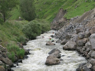
The river flows close to the road all the time, one can road scout most of the rapids. The beginning is quite easy, then there is a rapid with an undercut in the middle - one can portage on the right bank of the river.
First big rapid with dangerous undercut at the reception. Easy portage on river right.

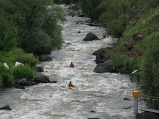
Afterwards the river gets steeper, boulder gardens and large holes. Most of the rapids can be scouted from kayak. Warning: in 2012 there were some construction works, and some concrete/metal obstacles in the river!
Steep cataract created by hydropower construction. This looks like the site of the HEP, a bridge follows, watch out for metal bars and cables.
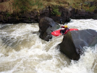
View from the bridge downstream. Powerful class 4.


At the end there is the most difficult section, steep and with large holes. It's difficult to setup a safety - on the left bank there is an undercut (?). You can scout from the left (there is last eddy on the left, but you'll notice the rapid very late).
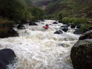
The most difficult rapid. (beginning)
The most difficult rapid. (end, middle)


It's worthwhile to do also the lower section down to the confluence in Khertvisi.
Lower
- Put-in: at the end of the upper section
- Take-out: Khertvisi village, an the right bank of the river, close to the river mouth (Khertvisi castle is just on the left side of the bridge).
- Length: 10 km
- Time: 2 h
- Gradient:
- Difficulty: 2-3+ (4)
- Last update: 2012 r.
The section is definitely easier than the upper one, mainly class 3, but with few more difficult rapids.
Water level
GPS coordinates
Map
External links
| To jest tylko zalążek artykułu. Jeśli potrafisz, rozbuduj go. |
| Ten artykuł należałoby zilustrować krótkim filmem. Jeśli posiadasz taki, dodaj go. |
| W tym opisie brakuje współrzędnych GPS. Jeśli je posiadasz, dodaj sekcję Współrzędne GPS |