Mtkvari/en
| Rzeki w okolicy |
|
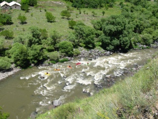
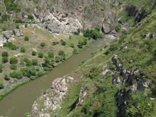
Mtkvari (Georgian: მტკვარი, Turkish: Kura, Azerbaijanian: Kür) is with about 1500 km the longest river of the Caucasus. Taking its spring in the high plains of Ardahan the river flows in the most Northeast corner of Turkey. Approaching towards the border with Georgia Kura river enters a deep gorge, which probably haven't seen any paddlers yet. Unfortunately there are hydropower works going on at the moment (Nov 2012). On the Georgian side of the border the most popular kayak sections around the cave city of Vardzia starts. The small camp site opposite of the cave city serves as basecamp. Most kayakers put-in here to paddle the Tmgovi Gorge. This most famous section of Mtkvari can be every thing between an easy class 3 bimble (in summer) and a challenging big water class 4-5 (May/June). Most paddlers finish near the village of Khertvisi but there's nothing to hold you to go further to Akhaltsikhe (two more days) or Borjomi (four more days). It is even possible to reach Tbilisi by boat (about ten days of paddling).
Spis treści |
River Sections
Standard
- Put-in: on the right bank of the river, close to restaurant/campsite close to "cave city"
- Take-out: on the road bridge. It's possible to paddle further down.
- Length: 10-15 km
- Time: 2-2.5 h
- Gradient:
- Difficulty: 2-3 (3+)
- Last update: 2012 r.
The section is easy, but very picturesque. In the middle of the section there are huge boulders in the riverbed, some of them are undercut, and there are a few siphons.
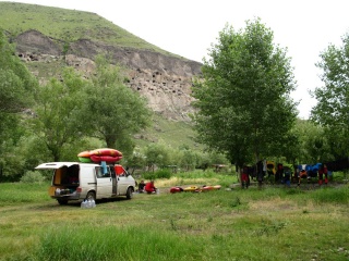
Campsite close the "cave city"


Water level
GPS coordinates
Map
External links
| To jest tylko zalążek artykułu. Jeśli potrafisz, rozbuduj go. |
| W tym artykule brakuje zdjęć. Jeśli posiadasz odpowiednie, dodaj je. |
| Ten artykuł należałoby zilustrować krótkim filmem. Jeśli posiadasz taki, dodaj go. |
| W tym opisie brakuje współrzędnych GPS. Jeśli je posiadasz, dodaj sekcję Współrzędne GPS |