Firtina/en
| Firtina | |
| Country | Turkey |
| Region | Black Sea Coast |
| Class | 3-5 (X) |
| Map | Firtina |
| Tributaries |
?? |
| Mouth | Black Sea |
Firtina (Fırtına) is one of the most interesting rivers on the Black Sea coast. This region receives a lot or precipitation (as clouds are coming from the Black Sea and stop on the mountains). That makes it possible to run rivers even in the high summer.
There is a road all the time along the river, and in most places it is possible to do "road scouting" (except for the gorge at the castle).
To get there go from Trabzon the the east, after Pazar town take the road to Çamlıhemşin. Don't let yourself fool about the high number of raft companies. They operate only on the lower section, the middle and upper sections are "kayakers only". Ca. 5 km above Çamlıhemşin there is the "Otel Doga" hotel. Its run by the well-travelled Idris and it the perfect base to explore the valleys. Idris speaks fluent English and French! There is no camping facilities near the hotel, but Idris might suggest you some places further upstream. Anyway, the rooms are not expensive and food is delicious.
Spis treści |
River Sections
Upper
- Put-in: near the main village Cat, it is worth to drive up the left valley for about 2 km.
- Take-out: on the left bank of the river, paddle as long as you dare to, but be aware of numerous class 5 and 6 sections.
- Length: ?? km
- Time: a few hours
- Gradient: ??? ‰
- Difficulty: 3-5 (6,X)
- Last update: 2012 r.
We drove up the valley quite a long way above the castle gorge. We started on the left-hand tributary upstream of the village Cat right at a class 4-5 rapid, very steep, fast, shallow. Afterwards it happened to be class 3-4, 3. Then we had a long portage (it's worthwhile to recognize it from the road while driving up the valley), and then up to class 5, and another portage. We finished there.
Paddling on this section was quite exploratory. Gradient regular (portages much steeper, with huge boulders). River flows fast, eddies are often very small. Most of the rapids one can scout from the road.
Upper Firtina

Above the Gorge
- Put-in: bridge where the road changes from left to right
- Take-out: bridge where the road changes from right to left (last bridge before the castle gorge). To get there drive a road coming to Zilkale castle, and further up.
- Length:
- Time:
- Gradient:
- Difficulty:
- Last update: r.
section description is missing
Section above the gorge looks as if it is quite steep. Warning: in case of swimming, the kayak might end up in the gorge!
The Gorge
- Put-in: on the bridge above the gorge. To get there drive a road coming to Zilkale castle, and further up.
- Take-out: on the bridge below the gorge, on the left bank of the river.
- Length:
- Time:
- Gradient:
- Difficulty: 4-5?
- Last update: r.
section description is missing
Section which requires just a small amount of water! The road is far way up, and leaving the gorge is virtually impossible.
Below the Gorge
- Put-in: on the bridge below the gorge, on the left bank of the river (a few km above "otel doga").
- Take-out: at the police station, on the left bank of the river.
- Length:
- Time: 2-2.5 h
- Gradient:
- Difficulty: 3-4 (4/4+, 5) (water level 30 cm on the gauge below the class 5 rapid)
- Last update: 2012 r.
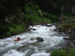
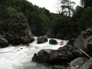
Beginning quite easy, class 3+. Before "Otel Doga" interesting rapid class 4-4+, big water, which large stoppers. After ca. 30 minutes one arrives to "Otel Doga". Afterwards more interesting. It may be worthwhile to scout a few rapids.

At the end most difficult rapid, class 5. It's very long and steep, large boulders, big water, some siphons. One can scout from the left bank of the river. Setting up safety is difficult, especially that there are not too many eddies.
Rapid before the main rapid
Main rapid (part)
Main rapid (part)


Standard
- Put-in: on the left bank of the river, above Çamlıhemşin, close to the police station.
- Take-out: on the bridge above the quarry.
- Length:
- Time: 2-2.5 h
- Gradient:
- Difficulty: 4-3 (4+/5-, 4+/5-) (88-93 cm on gauge in the middle of the section)
- Last update: 2012 r.
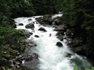
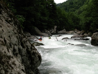
From the beginning quite regular, a few stoppers behind the boulders (some of them quite powerful, depending on the water lewel). After some time large hole at a boulder weir - it's possible to scout from the left bank of the river. There is a kicker on the weir. Next difficult rapid - large boulders, left part goes to the undercut, on the right side - drop, ca. 2.5m. One can setup safety on the right bank of the river.


Afterwards the most difficult rapid with a big undercut ledge on the left and enormous holes. You can scout from the left bank of the river, on the right side - chicken line.
Further down a long class 4 rapid. There are several big water rapids on the sections. River can be more difficult with higher water level!
Lower
- Put-in: on the bridge above the quarry.
- Take-out: Black Sea
- Length:
- Time:
- Gradient:
- Difficulty:
- Last update: r.
section description is missing
The easiest section, runnable by rafts. It's worth doing if the water level is high (too high for the other sections).
Water level
GPS Coordinates
Map
External links
| To jest tylko zalążek artykułu. Jeśli potrafisz, rozbuduj go. |
| W tym artykule brakuje zdjęć. Jeśli posiadasz odpowiednie, dodaj je. |
| Ten artykuł należałoby zilustrować krótkim filmem. Jeśli posiadasz taki, dodaj go. |
| W tym opisie brakuje współrzędnych GPS. Jeśli je posiadasz, dodaj sekcję Współrzędne GPS |