Untertalbach/en
| Untertalbach | |
| Kraj | Austria |
| Rejon | Steiermark |
| Trudność | WW V |
| Mapka | Untertalbach |
| Dopływy |
?? |
| Ujście do | ? |
| Rzeki w okolicy |
Untertalbach is a small river (or a creek), which, in connection with Obertalbach makes Talbach, which finally has a mouth in Enns.
You can arrive there with by the road 320/E651 to Schladming, then along Talbach to Untertal.
Spis treści |
River Sections
Upper Untertalbach
Missing description
- Start
- End
- Length
Untertalbachklamm
- Start: bridge on Untertalbach
- End: bridge on Untertalbach in Untertal, close to the gauge (gauge on the left river bank)
- Length: 2 km
- Time: 30 min - few hours
- Gradient: 50 ‰
- Difficulty: WW V
Warning: possible trees in the river
This part is so-called Wasserfallstrecke, with a big gradient i lots of dropa and slides (mostly till 2-3 m, but the highest one 8 m). You can scout whole part along the left bank, but not everywhere there is a good access to the river.
Detailed description
- After starting bridge horseshoe - a drop in the horseshoe shape. I begins with a slide with a big towback.
Należy płynąć po językach (najlepiej lewą), z bardzo dużą szybkością. Po kabinie może wyrzucić kajakarza za odwój nawet kilka metrów poniżej (wbija pod wodę). Możliwa asekuracja z prawego brzegu.

Untertalbachklamm - Horseshoe - LW

Untertalbachklamm - Stopper after Horseshoe - LW


- After ca. 100 m after the horseshoe, the canyon begins,
- Następnie jest duża skała na środku rzeki (rozdwajająca nurty), i duży spadek na obu rozdwojeniach. Należy płynąć lewą stroną, gdyż po prawej jest podmyta skała.

Untertalbachklamm - Skala rozdzielajaca nurty - napłynięcie przy LW

- After ca. 100m there is a highest waterfall (ca. 8 m), vertical. You can scout it from the right bank (from the left bank there is a problem with access to the river). Best way to go is the left side. There should not be a towback under the waterfall, but you should rather boof.
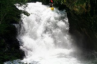
Untertalbachklamm - Najwyższy wodospad

- Afterwards there is an eddy and a slide

Untertalbachklamm - Slide after Waterfall - LW

- Then a narrow "S" (before it a bigeddy on the left) and a left turn. On the end a skośny stopper, which you are to boof from left to right (on the left there is an undercut),

- After ca. 100 m canyon opens, then you can see a wooden bridge, you should stop before (eddy in the right) and scout following Mühlerutsche cataract - a high, irregular slide. On the right bank old mill. The cataract looks worse that it really is. You can paddle left (easier one) or centre - there is a big rock that ... mocno wybija w górę, but you should watch out for undercut and a stopper,

Untertalbachklamm - Mühlerutsche - left side - LW

Untertalbachklamm - Mühlerutsche - center - LW


- After few hundred meters big eddy on the right and Silberkatarakt begins - most difficult and quiet dangerous place, a long one (ca. 150 m). It begins with some kind of slide on the plate, on both river sides there are undercuts, that a stopper - you can protect from the left, but it is difficult to reach the river there. Afterwards the current splits into two branches - on the left side there is a plate (paddleable), but the most of the water goes right, to a harder branch. At the end a stopper and two "S".

Silberkatarakt

Silberkatarakt

Silberkatarakt

Silberkatarakt


- Ostatnie miejsce do skośny drop, po lewej stronie podmyta skała. Nie należy pływać przy zbyt małej wodzie.
Water level
Gauge is located under the bridge in Untertal, at the end of Untertalbachklamm section
Water levels:
- LW: 100 cm,
- MW: 110-120 cm
- HW: 140?
Below 100 cm you can also paddle Untertalbachklamm (90 cm is enough).
Photos
GPS Coordinates
Map
<googlemap version="0.9" lat="47.36563" lon="13.687763" type="map" zoom="14" scale="yes" overview="yes"> (B) 47.373043, 13.676824 Untertalbachklamm Gauge and End 47.358017, 13.694497 Untertalbachklamm Podkowa 47.358665, 13.692442 Untertalbachklamm Canyon 47.359637, 13.691832 Untertalbachklamm Waterfall 8m 47.35984, 13.691013 Untertalbachklamm Muhlerutsche 6#B2758BC5 (A) 47.357507, 13.697359 Untertalbachklamm Start 47.357828, 13.693873 47.361182, 13.690639 47.363496, 13.688036 47.365793, 13.684989 47.366171, 13.681857 47.367391, 13.681771 47.37307, 13.676691 </googlemap>
See also
External links
| Ten artykuł należałoby zilustrować krótkim filmem. Jeśli posiadasz taki, dodaj go. |