Ilica/en
m |
m |
||
| Linia 31: | Linia 31: | ||
The beginning goes through quite steep boulder rapids, class 4, afterwards it's getting easier but keeps its continuous characater, class 3. This section requires a bit more water. After a few kilometers it's getting steeper again and the most interesting river part begins. It looks like there is more water here. Some of the rapids should be scouted, there are even a few bed rock slides. Take care about the holes in higher water, class 4-5. Warning: In June 2012 there were constructions works going on near the center of Meydancik village. A new dam is going to be built and will divert the water to a new HEP directly before the next dam (at the take-out). The river flowed through concrete pipes, construction debris is possible. From the pipes it's getting much steeper and you approach the most difficult rapid close to the road tunnel (road goes on the left bank of the river, it's possible to see the river from the river bank, it's quite far though. Warning: there were some metal obstacles in the river (2012r.) | The beginning goes through quite steep boulder rapids, class 4, afterwards it's getting easier but keeps its continuous characater, class 3. This section requires a bit more water. After a few kilometers it's getting steeper again and the most interesting river part begins. It looks like there is more water here. Some of the rapids should be scouted, there are even a few bed rock slides. Take care about the holes in higher water, class 4-5. Warning: In June 2012 there were constructions works going on near the center of Meydancik village. A new dam is going to be built and will divert the water to a new HEP directly before the next dam (at the take-out). The river flowed through concrete pipes, construction debris is possible. From the pipes it's getting much steeper and you approach the most difficult rapid close to the road tunnel (road goes on the left bank of the river, it's possible to see the river from the river bank, it's quite far though. Warning: there were some metal obstacles in the river (2012r.) | ||
| − | < | + | <galleryHorizontal> |
Image:Ilica_Upper_LW_Topik_Scheuer1.jpg|Upper Ilica (LW) | Image:Ilica_Upper_LW_Topik_Scheuer1.jpg|Upper Ilica (LW) | ||
Image:Ilica_Upper_LW_Scheuer_Luki_Topik_obok_tunelu.jpg|Close to the tunnel | Image:Ilica_Upper_LW_Scheuer_Luki_Topik_obok_tunelu.jpg|Close to the tunnel | ||
| − | </ | + | </galleryHorizontal> |
{{RiverSection | {{RiverSection | ||
Wersja z 20:29, 18 lis 2012
| Rzeki w okolicy |
|
This river has different names, depending on which map you read or who you ask :-) Ilica is the official Turkish name, Imerhev is the Georgian name which is widely used by the local population.
To get there go along the Berta/en river and then head to Meydancik village.
Spis treści |
River sections
Upper
- Put-in: on the left bank of the river, as far up as you can go (close to military buildings).
- Take-out: on the left bank of the river, next to the main road, right before a dam
- Length: xx km
- Time: 3 h+
- Gradient:
- Difficulty: 3-5
- Last update: 2012 r.
This section you should start as far up as you can go. We started just below a military post (it's very close to Georgian border).
The beginning goes through quite steep boulder rapids, class 4, afterwards it's getting easier but keeps its continuous characater, class 3. This section requires a bit more water. After a few kilometers it's getting steeper again and the most interesting river part begins. It looks like there is more water here. Some of the rapids should be scouted, there are even a few bed rock slides. Take care about the holes in higher water, class 4-5. Warning: In June 2012 there were constructions works going on near the center of Meydancik village. A new dam is going to be built and will divert the water to a new HEP directly before the next dam (at the take-out). The river flowed through concrete pipes, construction debris is possible. From the pipes it's getting much steeper and you approach the most difficult rapid close to the road tunnel (road goes on the left bank of the river, it's possible to see the river from the river bank, it's quite far though. Warning: there were some metal obstacles in the river (2012r.)
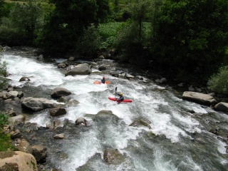
Upper Ilica (LW)
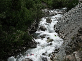
Close to the tunnel


The Gorges
- Put-in: below the upper dam
- Take-out: at the lower HEP (main road crosses to right bank)
- Length:
- Time:
- Gradient:
- Difficulty: WW 3-4+ ?
- Last update: r.
brak opisu odcinka
Warning: the upper dam might take most of the water - in June 2012 it was too low water level for the section
Lower
- Put-in: at the lowest HEP (main road crosses to the right bank), good parking and river access 150 m below the bridge
- Take-out: ?
- Length:
- Time:
- Gradient:
- Difficulty: WW 3-4 ?
- Last update: r.
brak opisu odcinka
Water level
GPS coordinates
Map
External links
| To jest tylko zalążek artykułu. Jeśli potrafisz, rozbuduj go. |
| W tym artykule brakuje zdjęć. Jeśli posiadasz odpowiednie, dodaj je. |
| Ten artykuł należałoby zilustrować krótkim filmem. Jeśli posiadasz taki, dodaj go. |
| W tym opisie brakuje współrzędnych GPS. Jeśli je posiadasz, dodaj sekcję Współrzędne GPS |