Ilica/en
m |
m (→Map) |
||
| (Nie pokazano 17 wersji utworzonych przez 2 użytkowników) | |||
| Linia 19: | Linia 19: | ||
{{RiverSection | {{RiverSection | ||
|name=Upper | |name=Upper | ||
| − | |putin= | + | |putin=upstream of Meydancik, coming up the main road, don't cross the river but, follow a small road to a village, after the road turns muddy and descends to river level, go as far up as you water level permis (soldiers mights stop you when you approach a military post). |
| − | |takeout=on the left bank of the river, next to the main road, right before a dam | + | |takeout=on the left bank of the river, next to the main road, right before a dam; if you want to avoid the tunnel cataract take out at the main road bridge |
| − | |length= | + | |length=8,5 km |
|time=3 h+ | |time=3 h+ | ||
|gradient= | |gradient= | ||
| − | |difficulty=3-5 | + | |difficulty=class 3-5 |
|update=2012 | |update=2012 | ||
}} | }} | ||
| − | This section you should start as far up as you can go. We started just below a military post (it's very close to Georgian border). | + | This section you should start as far up as you can go. We started just below a military post (it's very close to the Georgian border). |
| − | The beginning goes through quite steep boulder rapids, class 4, afterwards it's getting easier but keeps its continuous characater, class 3. This section requires a bit more water. After a few kilometers it's getting steeper again and the most interesting river part begins. It looks like there is more water here. Some of the rapids should be scouted, there are even a few bed rock slides. Take care about the holes in higher water, class 4-5. Warning: In June 2012 there were constructions works going on near the center of Meydancik village. A new dam is going to be built and will divert the water to a new HEP directly before the next dam (at the take-out). The river flowed through concrete pipes, construction debris is possible. | + | The beginning goes through quite steep boulder rapids, class 4, afterwards it's getting easier but keeps its continuous characater, class 3. This section requires a bit more water. After a few kilometers it's getting steeper again and the most interesting river part begins. It looks like there is more water here. Some of the rapids should be scouted, there are even a few bed rock slides. Take care about the holes in higher water, class 4-5. Warning: In June 2012 there were constructions works going on near the center of Meydancik village. A new dam is going to be built and will divert the water to a new HEP directly before the next dam (at the take-out). The river flowed through concrete pipes, construction debris is possible. Shortly after you pass the main road bridge. Get out here if you are not into adrenaline! Right after the bridge you approach the most difficult rapid. Best is to scout right, but keep to the water and don't destroy the meadow. The farmer will appreciate it! The more you approach to the road tunnel, the steeper it gets. The rapid right after the tunnel is a nasty class 6 with concrete and metal stakes. (June 2012r.)Better stick to the easy portage left. Scout the take-out before from the road as debris and sedimentation might change the eddy. (road goes on the left bank of the river, it's possible to see the river from the river bank, it's quite far though. |
<galleryHorizontal> | <galleryHorizontal> | ||
Image:Ilica_Upper_LW_Topik_Scheuer1.jpg|Upper Ilica (LW) | Image:Ilica_Upper_LW_Topik_Scheuer1.jpg|Upper Ilica (LW) | ||
| − | Image:Ilica_Upper_LW_Scheuer_Luki_Topik_obok_tunelu.jpg| | + | Image:Ilica_Upper_LW_Scheuer_Luki_Topik_obok_tunelu.jpg|Rapid next to the tunnel. Catch the eddy right at the end. The next one is nasty ... |
</galleryHorizontal> | </galleryHorizontal> | ||
| Linia 40: | Linia 40: | ||
|putin=below the upper dam | |putin=below the upper dam | ||
|takeout=at the lower HEP (main road crosses to right bank) | |takeout=at the lower HEP (main road crosses to right bank) | ||
| − | |length= | + | |length=5,5 km |
|time= | |time= | ||
|gradient= | |gradient= | ||
| − | |difficulty= | + | |difficulty=class 3-4+ ? |
|update= | |update= | ||
}} | }} | ||
| Linia 52: | Linia 52: | ||
{{RiverSection | {{RiverSection | ||
| − | |name= | + | |name=The wooden gorge |
|putin=at the lowest HEP (main road crosses to the right bank), good parking and river access 150 m below the bridge | |putin=at the lowest HEP (main road crosses to the right bank), good parking and river access 150 m below the bridge | ||
| − | |takeout= | + | |takeout=small road bridge with the gauge |
| − | |length= | + | |length= 2,5 km |
| − | |time= | + | |time= 45 min |
|gradient= | |gradient= | ||
| − | |difficulty= | + | |difficulty=class 3-4 |
| − | |update= | + | |update=2012 |
}} | }} | ||
| − | + | Short, but very nice section which is worh to attach to the gorge above if you find water there. If your group is strong enough it is also a great prelude to the lower Ilica. Right after the start the river cuts into the narrow valley and consists of an endless serials of class 3-4 rapids with small pools and occasional holes (4+ in high water). With good water levels the whole section is very pleasant and surprisingly fast. No particular dangers. You can also paddle that section with very low water (gauge 42 cm). Despite the scraping it is then a nice initiation into low volume creeking (class 3+). | |
| + | <galleryVertical> | ||
| + | Image:ilica_lower_rapid_near_start.jpg|This pool'n'drop rapids is typical for the first three kilometres. (LW) | ||
| + | </galleryVertical> | ||
| + | |||
| + | {{RiverSection | ||
| + | |name=Lower | ||
| + | |putin=small road bridge with the gauge | ||
| + | |takeout=road bridge netween Artvin and Savsat, 100 m before the confluence with Berta Suyu | ||
| + | |length= 13 km | ||
| + | |time= 2,5 h | ||
| + | |gradient= | ||
| + | |difficulty=2-3 (4+) | ||
| + | |update=2012 | ||
| + | }} | ||
| + | |||
| + | The Lower Ilica is the most easiest part which keeps the water longest. Nevertheless it is not recommanded with very low water as often the water gets lost in the wide gravel bed, also in midsummer the water quality is very poor (probably due to eutrophication). You shaould have at least 50 cm at the gauge. | ||
| + | |||
| + | Towards the end when nobody expects any surprises, take great caution: a rapid next to a steep slope on river left gets steeper and ends in a boulder chaos. It is very easy to miss, there are only small eddies after you've entered the rapid. The current shoots directly against a mid-size boulder which is forming a huge siphon. Probably the siphon is less dangerous with more water. At least in low water it is a real trap as you barely notice it even by scouting. Portage on the right side goes over boulders and will take you 10 min. | ||
| + | |||
| + | |||
| + | <galleryVertical> | ||
| + | Image:iliica_lower_easy_section.jpg|After the wooden gorge the river is mostly easy in an open walley. | ||
| + | Image:ilica_lower_cataract_siphon_1.jpg|The most difficult rapid with the siphon in the end. (LW) | ||
| + | Image:ilica_lower_cataract_siphon2.jpg|The siphon from below. | ||
| + | </galleryVertical> | ||
== Water level == | == Water level == | ||
| + | |||
| + | Till recently a good water level in spring and early summer was guaranteed. Due to different HEP projects the season got shorter. The best value you get by coming in May or June. In July you might find water on the lower sections, after the river is too low. There are a few gauges all along the river. For the middle and lower sections we use the one at the put-in of lower Ilica. You should have at least 45 cm for the wooden gorge and 50 cm for the lower Ilica. The diverted gorge above the HEP probably needs at least 80 cm. | ||
| + | |||
== GPS coordinates == | == GPS coordinates == | ||
* {{gpsentry|Upper Ilica put-in|41.461710°N|42.177700°E}} | * {{gpsentry|Upper Ilica put-in|41.461710°N|42.177700°E}} | ||
| Linia 72: | Linia 100: | ||
== Map == | == Map == | ||
| − | {{ | + | {{Map}} |
== External links == | == External links == | ||
| − | + | {{GPSEn}} | |
| − | {{ | + | |
| − | + | ||
| − | + | ||
| − | + | ||
Aktualna wersja na dzień 10:12, 14 gru 2012
| Other rivers |
|
This river has different names, depending on which map you read or who you ask :-) Ilica is the official Turkish name, Imerhev is the Georgian name which is widely used by the local population.
To get there go along the Berta/en river and then head to Meydancik village.
Spis treści |
River sections
Upper
- Put-in: upstream of Meydancik, coming up the main road, don't cross the river but, follow a small road to a village, after the road turns muddy and descends to river level, go as far up as you water level permis (soldiers mights stop you when you approach a military post).
- Take-out: on the left bank of the river, next to the main road, right before a dam; if you want to avoid the tunnel cataract take out at the main road bridge
- Length: 8,5 km
- Time: 3 h+
- Gradient:
- Difficulty: class 3-5
- Last update: 2012 r.
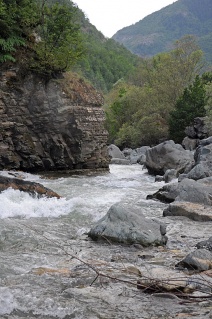
This section you should start as far up as you can go. We started just below a military post (it's very close to the Georgian border).
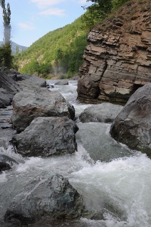
The beginning goes through quite steep boulder rapids, class 4, afterwards it's getting easier but keeps its continuous characater, class 3. This section requires a bit more water. After a few kilometers it's getting steeper again and the most interesting river part begins. It looks like there is more water here. Some of the rapids should be scouted, there are even a few bed rock slides. Take care about the holes in higher water, class 4-5. Warning: In June 2012 there were constructions works going on near the center of Meydancik village. A new dam is going to be built and will divert the water to a new HEP directly before the next dam (at the take-out). The river flowed through concrete pipes, construction debris is possible. Shortly after you pass the main road bridge. Get out here if you are not into adrenaline! Right after the bridge you approach the most difficult rapid. Best is to scout right, but keep to the water and don't destroy the meadow. The farmer will appreciate it! The more you approach to the road tunnel, the steeper it gets. The rapid right after the tunnel is a nasty class 6 with concrete and metal stakes. (June 2012r.)Better stick to the easy portage left. Scout the take-out before from the road as debris and sedimentation might change the eddy. (road goes on the left bank of the river, it's possible to see the river from the river bank, it's quite far though.
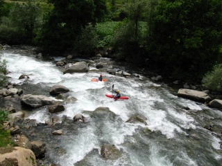
Upper Ilica (LW)
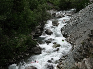
Rapid next to the tunnel. Catch the eddy right at the end. The next one is nasty ...


The Gorges
- Put-in: below the upper dam
- Take-out: at the lower HEP (main road crosses to right bank)
- Length: 5,5 km
- Time:
- Gradient:
- Difficulty: class 3-4+ ?
- Last update: r.
section description is missing
Warning: the upper dam might take most of the water - in June 2012 it was too low water level for the section
The wooden gorge
- Put-in: at the lowest HEP (main road crosses to the right bank), good parking and river access 150 m below the bridge
- Take-out: small road bridge with the gauge
- Length: 2,5 km
- Time: 45 min
- Gradient:
- Difficulty: class 3-4
- Last update: 2012 r.
Short, but very nice section which is worh to attach to the gorge above if you find water there. If your group is strong enough it is also a great prelude to the lower Ilica. Right after the start the river cuts into the narrow valley and consists of an endless serials of class 3-4 rapids with small pools and occasional holes (4+ in high water). With good water levels the whole section is very pleasant and surprisingly fast. No particular dangers. You can also paddle that section with very low water (gauge 42 cm). Despite the scraping it is then a nice initiation into low volume creeking (class 3+).
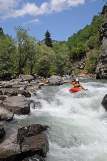
This pool'n'drop rapids is typical for the first three kilometres. (LW)

Lower
- Put-in: small road bridge with the gauge
- Take-out: road bridge netween Artvin and Savsat, 100 m before the confluence with Berta Suyu
- Length: 13 km
- Time: 2,5 h
- Gradient:
- Difficulty: 2-3 (4+)
- Last update: 2012 r.
The Lower Ilica is the most easiest part which keeps the water longest. Nevertheless it is not recommanded with very low water as often the water gets lost in the wide gravel bed, also in midsummer the water quality is very poor (probably due to eutrophication). You shaould have at least 50 cm at the gauge.
Towards the end when nobody expects any surprises, take great caution: a rapid next to a steep slope on river left gets steeper and ends in a boulder chaos. It is very easy to miss, there are only small eddies after you've entered the rapid. The current shoots directly against a mid-size boulder which is forming a huge siphon. Probably the siphon is less dangerous with more water. At least in low water it is a real trap as you barely notice it even by scouting. Portage on the right side goes over boulders and will take you 10 min.
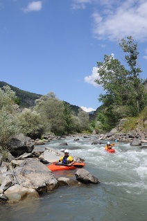
After the wooden gorge the river is mostly easy in an open walley.
The most difficult rapid with the siphon in the end. (LW)
The siphon from below.


Water level
Till recently a good water level in spring and early summer was guaranteed. Due to different HEP projects the season got shorter. The best value you get by coming in May or June. In July you might find water on the lower sections, after the river is too low. There are a few gauges all along the river. For the middle and lower sections we use the one at the put-in of lower Ilica. You should have at least 45 cm for the wooden gorge and 50 cm for the lower Ilica. The diverted gorge above the HEP probably needs at least 80 cm.
GPS coordinates
Map
External links
| This article is missing GPS coordinates. It you know them, add them into GPS Coordinates section |