Firtina/en
m |
|||
| (Nie pokazano 26 wersji utworzonych przez 2 użytkowników) | |||
| Linia 1: | Linia 1: | ||
| − | {{ | + | {{Languages|Firtina}} |
| − | | | + | {{River |
| − | | | + | | name=Firtina |
| − | | | + | | country=Turkey |
| − | | | + | | difficulty=3-5 (X) |
| + | | region=Black Sea Coast | ||
| + | | mouth=Black Sea | ||
}} | }} | ||
| − | {{ | + | {{OtherRivers | |
| − | * [[Ayder]] | + | * [[Ayder/en]] |
| − | * [[Firtina]] | + | * [[Firtina/en]] |
}} | }} | ||
| − | [[Firtina]] (Fırtına) | + | [[Firtina]] (Fırtına) is one of the most interesting rivers on the Black Sea coast. This region receives a lot or precipitation (as clouds are coming from the Black Sea and stop on the mountains). That makes it possible to run rivers even in the high summer. |
| − | + | There is a road all the time along the river, and in most places it is possible to do "road scouting" (except for the gorge at the castle). | |
| − | + | To get there go from Trabzon the the east, after Pazar town take the road to Çamlıhemşin. Don't let yourself fool about the high number of raft companies. They operate only on the lower section, the middle and upper sections are "kayakers only". Ca. 5 km above Çamlıhemşin there is the "Otel Doğa" hotel. Its run by the well-travelled Idris and it the perfect base to explore the valleys. Idris speaks fluent English and French! There is no camping facilities near the hotel, but Idris might suggest you some places further upstream. Anyway, the rooms are not expensive and food is delicious. | |
| − | == | + | |
| − | {{ | + | == River Sections == |
| − | | | + | {{RiverSection |
| − | | | + | |name=Upper |
| − | | | + | |putin=near the main village Çat, it is worth to drive up the left valley for about 2 km. |
| − | | | + | |takeout=on the left bank of the river, paddle as long as you dare to, but be aware of numerous class 5 and 6 sections. |
| − | | | + | |length=?? km |
| − | | | + | |time=a few hours |
| − | | | + | |gradient=??? ‰ |
| − | | | + | |difficulty=3-5 (6,X) |
| + | |update=2012 | ||
}} | }} | ||
| − | + | We drove up the valley quite a long way above the castle gorge. We started on the left-hand tributary upstream of the village Cat right at a class 4-5 rapid, very steep, fast, shallow. Afterwards it happened to be class 3-4, 3. Then we had a long portage (it's worthwhile to recognize it from the road while driving up the valley), and then up to class 5, and another portage. We finished there. | |
| − | + | Paddling on this section was quite exploratory. Gradient regular (portages much steeper, with huge boulders). River flows fast, eddies are often very small. Most of the rapids one can scout from the road. | |
| − | < | + | <galleryHorizontal> |
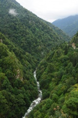
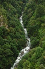
| − | Image:Firtina_Upper_1_Scheuer.jpg|Upper | + | Image:Firtina_Upper_1_Scheuer.jpg|Upper Fırtına above Çat (left branch). |
| − | </ | + | </galleryHorizontal> |
| − | {{ | + | {{RiverSection |
| − | | | + | |name=Above the Gorge |
| − | | | + | |putin=bridge where the road changes from left to right |
| − | | | + | |takeout=bridge where the road changes from right to left (last bridge before the castle gorge). To get there drive up the main valley towards Zilkale and Cat. After having passed the brandnew renovated Zilkale castle the so far paved road becomes a dirt road. It'll soon descends to a bridge which marks the take-out. |
| − | | | + | |length=2,2 km |
| − | | | + | |time= 30 min |
| − | | | + | |gradient= |
| − | | | + | |difficulty=4+ (5) |
| − | | | + | |update= august 2013 |
}} | }} | ||
| − | {{ | + | You can scout the whole section easily from the road. Check for trees before you start. Especially towards the end the rapids become very steep and fast with short pools. Only attempt in low water. When the water level at Doga Otel seems too low, this section might be still in good flow. If you intend to paddle the isolated Zilkale gorge, start with this section. The gorge is much harder than the roadside section. |
| + | {{MissingDescriptionEn}} | ||
| − | + | Warning: In case of swimming, the kayak might end up in the gorge! | |
| + | <galleryHorizontal> | ||
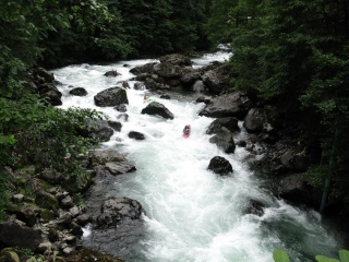
| + | Image:firtina_abovegorge_scheuerseb_1.jpg|Typical rapid. The picture is taken in low water mid of August 2013. | ||
| + | Image:firtina_abovegorge_scheuerseb_2.jpg|Little vertical cliffs in the core part. | ||
| + | Image:firtina_abovegorge_scheuerseb_3.jpg|One of the last rapids, seen from the take-out bridge. | ||
| + | </galleryHorizontal> | ||
| − | {{ | + | {{RiverSection |
| − | | | + | |name=Zilkale Gorge |
| − | | | + | |putin=on the bridge above the gorge. On the way up have a look down into the gorge from Zilkale main tower. Shortly after the road gets bad and descends to the put-in bridge. |
| − | | | + | |takeout=on the bridge below the gorge, on the left bank of the river. 100 m before the river there is a wild picknick and camping spot. |
| − | | | + | |length=6 km |
| − | | | + | |time= |
| − | | | + | |gradient= |
| − | | | + | |difficulty=4-5+ (6) |
| − | | | + | |update= august 2013 |
}} | }} | ||
| − | + | Seldomly run – take great care and attempt only in low water. August and September are the best months, but also then the water level might be too high due to rain. | |
| + | On your first run start at least 2 km before the put-in bridge to get a feeling for the river and water level. The Firtina is much more powerful than it looks from the road. The section till the bridge is easier than most parts of the gorge. Due to the humid climate the rocks in the gorge are very slippery. Wear good shoes and be prepared for hard walking and scrambling. The road is far way up, and leaving the gorge is virtually impossible. | ||
| − | + | The difficulties start when the river drops in a very short S-shaped canyon. The rapid is pretty easy but the final left bend wall is badly undercut. Hard to portage, take care! Shortly after huge rapids require scouting and at least two portages. Vertical cliffs allow to scout only at one bank, portaging involves scrambling over slippery boulders. Some of the huge rocks form siphons. This core section reminded us to the Wellerbrücke section of the Ötztaler Ache. Trees are likely to block some lines. After about 800 m it gets easier as you approach the castel. The rapids one can see from the Zilkale tower are one of the most easiest. | |
| + | In a while it gets steeper again. When an island splits the river in two arms (the right one is nearly dry), scout the left arm before running it. The clean rapid is a gem, but be sure to catch the eddy before the final 2 m drop. There is a huge hole and a nasty undercut boulder on the right. The lower parts is comparable to the Virgen gorge of Isel in Austria. After you've passed an old wooden footbridge the river calms down. | ||
| + | |||
| − | {{ | + | <galleryHorizontal> |
| − | | | + | Image:firtina_zilkaleview_1.jpg|So beautiful, so isolated. The gorge seen from Zilkale. |
| − | | | + | Image:firtina_zilkaleview_2.jpg|This rapid below the castle is one of the easier. |
| − | | | + | </galleryHorizontal> |
| − | | | + | |
| − | | | + | {{RiverSection |
| − | | | + | |name=Otel Doğa Run |
| − | | | + | |putin=on the bridge below the gorge (the road changes here from river lef to right), on the left bank of the river (4 km above "Otel Doğa"). |
| − | | | + | |takeout=last brigde before the Polis Evi cataract after the river has become flat. |
| + | |length=6,5 km | ||
| + | |time=2-2.5 h | ||
| + | |gradient= | ||
| + | |difficulty=3-4 (4/4+) (water level 30 cm on the gauge below the Polis Evi Cataract) | ||
| + | |update=2012 | ||
}} | }} | ||
| − | |||
| − | + | The section starts quite easy, class 3+. Before "Otel Doğa" there is an interesting big water rapid class 4-4+ which large stoppers and a cliff on the left side. After ca. 30 minutes (4 km) one arrives to the hotel. Afterwards the gradient increases and it may be worthwhile to scout a few rapids. After the road changes to river left, Fırtına soon becomes easier. Fast current in a wide gravel bed on the last 2 km. Be sure not to miss the take-out and enter accidentially the following cataracts. | |
| + | |||
| + | <galleryHorizontal> | ||
Image:Firtina_Below_Gorge_1.jpg| | Image:Firtina_Below_Gorge_1.jpg| | ||
| − | </ | + | </galleryHorizontal> |
| − | + | {{RiverSection | |
| + | |name=Polis Evi Cataract | ||
| + | |putin=Most padddlers continue from the Otel Doga run. If the water is too low for that, put-in at the small road bridge near the end of the flat section 2 km above Çamlıhemşin. | ||
| + | |takeout=at the police station ("polis evi") at the beginning of Çamlıhemşin, on the left bank of the river. | ||
| + | |length=1,7 km | ||
| + | |time=1-1.5 h (20 min if you know the lines) | ||
| + | |gradient= | ||
| + | |difficulty=4-5 (5+) (water level 30 cm on the gauge below the class 5 rapid) | ||
| + | |update=2012 | ||
| + | }} | ||
| − | |||
| − | |||
| − | |||
| − | |||
| − | |||
| − | {{ | + | This most serious part of the classical Fırtına sections consists of a very long and steep series of rapids between large boulders, big water, some siphons. More friendly in late summer and autumn. Don't attempt this run in high water. One can scout from the left bank of the river. Setting up safety is difficult, especially that there are not too large pools. |
| − | | | + | |
| − | | | + | <galleryHorizontal> |
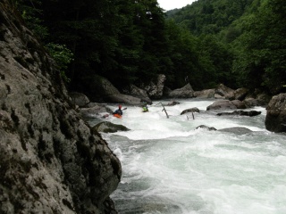
| − | | | + | Image:Firtina_Below_Gorge_Bystrze_przed_Katarakta.jpg|The storm taking breath – after this rapid you better get out and inspect. |
| − | | | + | Image:Firtina_Below_Gorge_Bystrze_Katarakta_Topik_Slodki.jpg|Part of the core section. (I) |
| − | | | + | </galleryHorizontal> |
| − | | | + | |
| − | | | + | {{RiverSection |
| − | | | + | |name=Çamlıhemşin Run |
| + | |putin=on the left bank of the river, above Çamlıhemşin, close to the police station. | ||
| + | |takeout=after the second class 5 rapid, before a long boulder cataract with a suspension bridge (waterfall and big Turkish flag in the left slope). | ||
| + | |length=8 km | ||
| + | |time=2-2.5 h | ||
| + | |gradient= | ||
| + | |difficulty=4-3 (4+/5-, 4+/5-) (88-93 cm on gauge in the middle of the section) | ||
| + | |update=2012 | ||
}} | }} | ||
| − | + | From the beginning quite regular, a few stoppers behind the boulders (some of them quite powerful, depending on the water lewel). After 2,5 km next to the petrol station large river-wide hole at a boulder weir - it's possible to scout from the left bank of the river. There is a kicker on the weir. Next difficult rapid - large boulders, left part goes to the undercut, on the right side - drop, ca. 2.5m. One can setup safety on the right bank of the river. | |
| − | < | + | <galleryHorizontal> |
Image:Firtina_Standard_1_Slodki.jpg| | Image:Firtina_Standard_1_Slodki.jpg| | ||
Image:Firtina_Standard_2_Topik.jpg| | Image:Firtina_Standard_2_Topik.jpg| | ||
| − | </ | + | </galleryHorizontal> |
| + | |||
| + | After 600 m the most difficult rapid with a big undercut ledge on the left and enormous holes. You can scout from the left bank of the river, on the right side - chicken line. | ||
| + | |||
| + | Another km down a long class 4 rapid (3+ in LW) with a suspension bridge which remarks the end of this section. However, most paddlers continue with the quarry run. There are several ''big water'' rapids on the sections. River can be more difficult with higher water level! | ||
| + | |||
| + | {{RiverSection | ||
| + | |name=Quarry Run | ||
| + | |putin=after the second class 5 rapid, before a long boulder cataract with a suspension bridge (waterfall and big Turkish flag in the left slope). | ||
| + | |takeout=small road bridge below the rafting restaurants. | ||
| + | |length=7km | ||
| + | |time=2h | ||
| + | |gradient= | ||
| + | |difficulty=3 (4+) | ||
| + | |update= | ||
| + | }} | ||
| + | |||
| + | the put-in avoids the two class 5 rapids of the Çamlıhemşin run. There's nothing remarkable at the put-in except a small place for raod-side parking and a tiny trail down to the water. After one km of class 2-3 you approach the first rapid with the suspension bridge. High in the left slope you note a big Turkish flag and a waterfall (might be dry in late summer). The rapid is a class 3 in low water but turns to a powerful 4 in high levels. Generally the whole section looks mostly easy from the road. But don't underestimate it, the hardest rapids are hidden. The first tricky one consists of a huge lateral wave over the whole width (class 3+). It is right next to a small electrical substation. | ||
| + | |||
| + | |||
| + | <galleryHorizontal> | ||
| + | Image:firtina_quarry_suspension_bridge.jpg|The first rapid with the suspension bridge. | Photo: Salome Fritz | ||
| + | Image:Firtina_quarry_electric_rapid_mathes.jpg|Not dangerous but powerful – this drop is next to the road but easy to miss. There is a small electrical substation next to it. | Photo: Salome Fritz | ||
| + | </galleryHorizontal> | ||
| + | |||
| + | Two rapids you want to scout before running them. At the begin of the quarry area there is a single rock with a Caykur sign. Just nextby is the rapid (class 4). That one is long, there is different lines regarding the water level and the skills of the paddlers. Soon you arrive at the slalom parcours (3+), great for eddy practising and playboating. Just below are the restaurants where the more ambitious raft trips start. Scout the next rapid, it looks artificial, has big holes and rocks in the receiption depending on the water level. Besides that the section is a great playrun which never gets boring. Especially good with big water in late spring and summer. | ||
| + | |||
| − | + | <galleryVertical> | |
| + | Image:firtina_quarry_slalom_parcours.jpg|The slalom parcours above the rafting restaurants (class 3+). | Photo: Salome Fritz | ||
| + | </galleryVertical> | ||
| + | <galleryHorizontal> | ||
| + | Image:Firtina_quarry_restaurant_rapid.jpg|The most difficult rapid next to the restaurant (class 4+). | Photo: Salome Fritz | ||
| + | </galleryHorizontal> | ||
| − | |||
| − | {{ | + | {{RiverSection |
| − | | | + | |name=Into the Black Sea |
| − | | | + | |putin=small road bridge below the rafting restaurants. |
| − | | | + | |takeout=Black Sea, right side 100 m aside the confluence. |
| − | | | + | |length=8 km |
| − | | | + | |time=2 h |
| − | | | + | |gradient= |
| − | | | + | |difficulty=2-3 (3+) |
| − | | | + | |update= |
}} | }} | ||
| − | |||
| − | + | The easiest section, runnable by rafts and duckies. It's worth doing it with beginners or if the water level is high (too high for the other sections). There are two weirs, first is a 1 m concrete barrier, which you better run in the right channel (on the left side there are metal stakes). The second one is a 1,5 m boulder weir. Scout it from the left, take one of the low-volume-chutes on the left or set your boof properly to fly over the hole on the right. After 2,5 km Tunca Dere is joining from the right. You can also start this section on Tunca at a bridge 2,2 km above the confluence. Shortly after the confluence the hardest rapid, a long gravel cataract with a huge hole in the middle. Take care with beginners. If you want to portage that get out well in advance on river left. Don't let you fool from the impression you get from the road. Even the last 3 km is well worth paddling and it's a great experience to reach the sea by boat. | |
| − | == | + | == Water level == |
| − | == | + | == GPS Coordinates == |
| − | + | * {{gpsentry|Bridge above the Gorge|40.939278°N|40.968056°E}} | |
| − | {{ | + | * {{gpsentry|Zilkale castle|40.959722°N|40.962220°E}} |
| + | * {{gpsentry|Bridge below the Gorge|40.980056°N|40.961972°E}} | ||
| + | * {{gpsentry|Otel Doğa|41.009030°N|40.991456°E}} | ||
| + | * {{gpsentry|Police in Çamlıhemşin|41.0421418°N|41.0074888°E}} | ||
| − | == | + | == Map == |
| − | + | {{Map|Firtina}} | |
| − | == | + | == External links == |
| − | + | ||
| − | {{ | + | {{movieEn}} |
| − | {{ | + | {{GPSEn}} |
| − | + | ||
| − | + | ||
Aktualna wersja na dzień 10:09, 19 sie 2013
| Firtina | |
| Country | Turkey |
| Region | Black Sea Coast |
| Class | 3-5 (X) |
| Map | Firtina |
| Tributaries |
?? |
| Mouth | Black Sea |
| Other rivers |
|
Firtina (Fırtına) is one of the most interesting rivers on the Black Sea coast. This region receives a lot or precipitation (as clouds are coming from the Black Sea and stop on the mountains). That makes it possible to run rivers even in the high summer.
There is a road all the time along the river, and in most places it is possible to do "road scouting" (except for the gorge at the castle).
To get there go from Trabzon the the east, after Pazar town take the road to Çamlıhemşin. Don't let yourself fool about the high number of raft companies. They operate only on the lower section, the middle and upper sections are "kayakers only". Ca. 5 km above Çamlıhemşin there is the "Otel Doğa" hotel. Its run by the well-travelled Idris and it the perfect base to explore the valleys. Idris speaks fluent English and French! There is no camping facilities near the hotel, but Idris might suggest you some places further upstream. Anyway, the rooms are not expensive and food is delicious.
Spis treści |
River Sections
Upper
- Put-in: near the main village Çat, it is worth to drive up the left valley for about 2 km.
- Take-out: on the left bank of the river, paddle as long as you dare to, but be aware of numerous class 5 and 6 sections.
- Length: ?? km
- Time: a few hours
- Gradient: ??? ‰
- Difficulty: 3-5 (6,X)
- Last update: 2012 r.
We drove up the valley quite a long way above the castle gorge. We started on the left-hand tributary upstream of the village Cat right at a class 4-5 rapid, very steep, fast, shallow. Afterwards it happened to be class 3-4, 3. Then we had a long portage (it's worthwhile to recognize it from the road while driving up the valley), and then up to class 5, and another portage. We finished there.
Paddling on this section was quite exploratory. Gradient regular (portages much steeper, with huge boulders). River flows fast, eddies are often very small. Most of the rapids one can scout from the road.
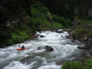
Upper Fırtına above Çat (left branch).

Above the Gorge
- Put-in: bridge where the road changes from left to right
- Take-out: bridge where the road changes from right to left (last bridge before the castle gorge). To get there drive up the main valley towards Zilkale and Cat. After having passed the brandnew renovated Zilkale castle the so far paved road becomes a dirt road. It'll soon descends to a bridge which marks the take-out.
- Length: 2,2 km
- Time: 30 min
- Gradient:
- Difficulty: 4+ (5)
- Last update: august 2013 r.
You can scout the whole section easily from the road. Check for trees before you start. Especially towards the end the rapids become very steep and fast with short pools. Only attempt in low water. When the water level at Doga Otel seems too low, this section might be still in good flow. If you intend to paddle the isolated Zilkale gorge, start with this section. The gorge is much harder than the roadside section.
section description is missing
Warning: In case of swimming, the kayak might end up in the gorge!
Typical rapid. The picture is taken in low water mid of August 2013.
Little vertical cliffs in the core part.
One of the last rapids, seen from the take-out bridge.


Zilkale Gorge
- Put-in: on the bridge above the gorge. On the way up have a look down into the gorge from Zilkale main tower. Shortly after the road gets bad and descends to the put-in bridge.
- Take-out: on the bridge below the gorge, on the left bank of the river. 100 m before the river there is a wild picknick and camping spot.
- Length: 6 km
- Time:
- Gradient:
- Difficulty: 4-5+ (6)
- Last update: august 2013 r.
Seldomly run – take great care and attempt only in low water. August and September are the best months, but also then the water level might be too high due to rain.
On your first run start at least 2 km before the put-in bridge to get a feeling for the river and water level. The Firtina is much more powerful than it looks from the road. The section till the bridge is easier than most parts of the gorge. Due to the humid climate the rocks in the gorge are very slippery. Wear good shoes and be prepared for hard walking and scrambling. The road is far way up, and leaving the gorge is virtually impossible.
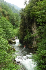
The difficulties start when the river drops in a very short S-shaped canyon. The rapid is pretty easy but the final left bend wall is badly undercut. Hard to portage, take care! Shortly after huge rapids require scouting and at least two portages. Vertical cliffs allow to scout only at one bank, portaging involves scrambling over slippery boulders. Some of the huge rocks form siphons. This core section reminded us to the Wellerbrücke section of the Ötztaler Ache. Trees are likely to block some lines. After about 800 m it gets easier as you approach the castel. The rapids one can see from the Zilkale tower are one of the most easiest. In a while it gets steeper again. When an island splits the river in two arms (the right one is nearly dry), scout the left arm before running it. The clean rapid is a gem, but be sure to catch the eddy before the final 2 m drop. There is a huge hole and a nasty undercut boulder on the right. The lower parts is comparable to the Virgen gorge of Isel in Austria. After you've passed an old wooden footbridge the river calms down.
So beautiful, so isolated. The gorge seen from Zilkale.
This rapid below the castle is one of the easier.


Otel Doğa Run
- Put-in: on the bridge below the gorge (the road changes here from river lef to right), on the left bank of the river (4 km above "Otel Doğa").
- Take-out: last brigde before the Polis Evi cataract after the river has become flat.
- Length: 6,5 km
- Time: 2-2.5 h
- Gradient:
- Difficulty: 3-4 (4/4+) (water level 30 cm on the gauge below the Polis Evi Cataract)
- Last update: 2012 r.
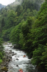
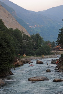
The section starts quite easy, class 3+. Before "Otel Doğa" there is an interesting big water rapid class 4-4+ which large stoppers and a cliff on the left side. After ca. 30 minutes (4 km) one arrives to the hotel. Afterwards the gradient increases and it may be worthwhile to scout a few rapids. After the road changes to river left, Fırtına soon becomes easier. Fast current in a wide gravel bed on the last 2 km. Be sure not to miss the take-out and enter accidentially the following cataracts.

Polis Evi Cataract
- Put-in: Most padddlers continue from the Otel Doga run. If the water is too low for that, put-in at the small road bridge near the end of the flat section 2 km above Çamlıhemşin.
- Take-out: at the police station ("polis evi") at the beginning of Çamlıhemşin, on the left bank of the river.
- Length: 1,7 km
- Time: 1-1.5 h (20 min if you know the lines)
- Gradient:
- Difficulty: 4-5 (5+) (water level 30 cm on the gauge below the class 5 rapid)
- Last update: 2012 r.
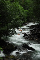
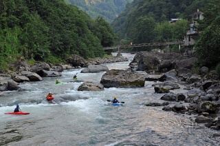
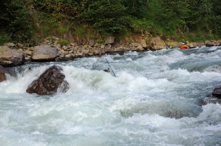
This most serious part of the classical Fırtına sections consists of a very long and steep series of rapids between large boulders, big water, some siphons. More friendly in late summer and autumn. Don't attempt this run in high water. One can scout from the left bank of the river. Setting up safety is difficult, especially that there are not too large pools.
The storm taking breath – after this rapid you better get out and inspect.
Part of the core section. (I)


Çamlıhemşin Run
- Put-in: on the left bank of the river, above Çamlıhemşin, close to the police station.
- Take-out: after the second class 5 rapid, before a long boulder cataract with a suspension bridge (waterfall and big Turkish flag in the left slope).
- Length: 8 km
- Time: 2-2.5 h
- Gradient:
- Difficulty: 4-3 (4+/5-, 4+/5-) (88-93 cm on gauge in the middle of the section)
- Last update: 2012 r.
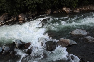
From the beginning quite regular, a few stoppers behind the boulders (some of them quite powerful, depending on the water lewel). After 2,5 km next to the petrol station large river-wide hole at a boulder weir - it's possible to scout from the left bank of the river. There is a kicker on the weir. Next difficult rapid - large boulders, left part goes to the undercut, on the right side - drop, ca. 2.5m. One can setup safety on the right bank of the river.


After 600 m the most difficult rapid with a big undercut ledge on the left and enormous holes. You can scout from the left bank of the river, on the right side - chicken line.
Another km down a long class 4 rapid (3+ in LW) with a suspension bridge which remarks the end of this section. However, most paddlers continue with the quarry run. There are several big water rapids on the sections. River can be more difficult with higher water level!
Quarry Run
- Put-in: after the second class 5 rapid, before a long boulder cataract with a suspension bridge (waterfall and big Turkish flag in the left slope).
- Take-out: small road bridge below the rafting restaurants.
- Length: 7km
- Time: 2h
- Gradient:
- Difficulty: 3 (4+)
- Last update: r.
the put-in avoids the two class 5 rapids of the Çamlıhemşin run. There's nothing remarkable at the put-in except a small place for raod-side parking and a tiny trail down to the water. After one km of class 2-3 you approach the first rapid with the suspension bridge. High in the left slope you note a big Turkish flag and a waterfall (might be dry in late summer). The rapid is a class 3 in low water but turns to a powerful 4 in high levels. Generally the whole section looks mostly easy from the road. But don't underestimate it, the hardest rapids are hidden. The first tricky one consists of a huge lateral wave over the whole width (class 3+). It is right next to a small electrical substation.
The first rapid with the suspension bridge. | Photo: Salome Fritz
Not dangerous but powerful – this drop is next to the road but easy to miss. There is a small electrical substation next to it. | Photo: Salome Fritz


Two rapids you want to scout before running them. At the begin of the quarry area there is a single rock with a Caykur sign. Just nextby is the rapid (class 4). That one is long, there is different lines regarding the water level and the skills of the paddlers. Soon you arrive at the slalom parcours (3+), great for eddy practising and playboating. Just below are the restaurants where the more ambitious raft trips start. Scout the next rapid, it looks artificial, has big holes and rocks in the receiption depending on the water level. Besides that the section is a great playrun which never gets boring. Especially good with big water in late spring and summer.
The slalom parcours above the rafting restaurants (class 3+). | Photo: Salome Fritz

The most difficult rapid next to the restaurant (class 4+). | Photo: Salome Fritz

Into the Black Sea
- Put-in: small road bridge below the rafting restaurants.
- Take-out: Black Sea, right side 100 m aside the confluence.
- Length: 8 km
- Time: 2 h
- Gradient:
- Difficulty: 2-3 (3+)
- Last update: r.
The easiest section, runnable by rafts and duckies. It's worth doing it with beginners or if the water level is high (too high for the other sections). There are two weirs, first is a 1 m concrete barrier, which you better run in the right channel (on the left side there are metal stakes). The second one is a 1,5 m boulder weir. Scout it from the left, take one of the low-volume-chutes on the left or set your boof properly to fly over the hole on the right. After 2,5 km Tunca Dere is joining from the right. You can also start this section on Tunca at a bridge 2,2 km above the confluence. Shortly after the confluence the hardest rapid, a long gravel cataract with a huge hole in the middle. Take care with beginners. If you want to portage that get out well in advance on river left. Don't let you fool from the impression you get from the road. Even the last 3 km is well worth paddling and it's a great experience to reach the sea by boat.
Water level
GPS Coordinates
Map
External links
| This article should be illustrated with a sample movie. If you have one, add it. |
| This article is missing GPS coordinates. It you know them, add them into GPS Coordinates section |