Barhal/en
m |
|||
| Linia 20: | Linia 20: | ||
{{RiverSection | {{RiverSection | ||
|name=Upper Upper | |name=Upper Upper | ||
| − | |putin= | + | |putin=on the left bank of the river, below class 5-6 rapids. |
| − | |takeout=na lewym brzegu, w okolicach "Pension Barhal" w wiosce Barhal (Altaparmak) | + | |takeout=on the left bank of the river, close to na lewym brzegu, w okolicach "Pension Barhal" w wiosce Barhal (Altaparmak) |
|length=12-14 km | |length=12-14 km | ||
|time=3.5 h | |time=3.5 h | ||
|gradient=? ‰ | |gradient=? ‰ | ||
| − | |difficulty= | + | |difficulty=class 3-4+ (4-5) |
|update=2012 | |update=2012 | ||
}} | }} | ||
| − | + | One can scout whole section while driving to the put-in. It is worth doing as afterwards you do not have to scout while paddling. In 2012 we put-in below class 5-6 rapids, but it is possible to drive a few km further to see what does the river look like there. Beggining is steep, class 4-5, with a portage in the middle of the rapid. | |
<gallery widths="320" heights="240" perrow="2"> | <gallery widths="320" heights="240" perrow="2"> | ||
| − | Image:Barhal_Upper_Upper_Scheuer_Start1.jpg| | + | Image:Barhal_Upper_Upper_Scheuer_Start1.jpg|Beginning of the first rapid. |
| − | Image:Barhal_Upper_Upper_Luki_Start2.jpg| | + | Image:Barhal_Upper_Upper_Luki_Start2.jpg|First rapid |
</gallery> | </gallery> | ||
| − | + | Afterwards slightly easier, class 4-4+, sometimes even class 3-2, but afterwards with class 4 rapids. River flows through many small gorges. Warning: trees (we had 2 portages due to trees). River is quite small, fast flowing, quite steep. Before the take out tghere is a difficult drop with huge towback (one can portage or take out before it). | |
{{RiverSection | {{RiverSection | ||
|name=Upper | |name=Upper | ||
| − | |putin= | + | |putin=at the take out of the Upper Upper Barhal, in Barhal village, on the left bank of the river. |
|takeout= | |takeout= | ||
|length= | |length= | ||
| Linia 49: | Linia 49: | ||
}} | }} | ||
| − | + | This section is more interesting than the upper one. At the beginning slightly easier, but with a few class 5 rapids. First one - small gorge with a siphon at the beginning. One can portage a siphon and put-in the the gorge (if there are eddies) or portage the whole gorge. Next class 5 rapid - a boulder garden (boulders just below the surface) and an undercut. Afterwards a few rapids 4+, big boulders. | |
| + | At the end of this part there is a drop (1.5 m) with a towback. | ||
| − | + | Afterwards difficulties are regular, class 3+-4+, all the time quite steep, sometimes a bit easier or a bit harder. Most of the time sounting not necessary (eddy hopping essential though). If it's your first run, you can do a lower section as well. | |
{{RiverSection | {{RiverSection | ||
|name=Lower | |name=Lower | ||
| − | |putin= | + | |putin=at the end of the upper section |
| − | |takeout= | + | |takeout=on the right bank of the river, in Yusufeli town, close to the Greepeace (Greenpiece) campsite |
|length= | |length= | ||
|time= | |time= | ||
| Linia 64: | Linia 65: | ||
}} | }} | ||
| − | + | Easy section, runnable als by rafts. A few rapids up to class 3. | |
| − | == | + | |
| − | == | + | == Gauge == |
| − | == | + | == GPS coordinates == |
| + | == Map == | ||
{{Mapa}} | {{Mapa}} | ||
Wersja z 13:12, 18 paź 2012
| Barhal | |
| Kraj | Turcja |
| Rejon | ? |
| Trudność | WW 3-6 (X) |
| Mapka | Barhal |
| Dopływy |
?? |
| Ujście do | Coruh Nehri |
| Rzeki w okolicy |
Barhal is one of the classic rivers in eastern Turkey. Sometimes it is called Altaparmak.
One can camp on the pickinc site above Barhal village, or in Yusufeli, at the Greenpeace campsite (at the end of the lower section).
Spis treści |
River Sections
Upper Upper
- Put-in: on the left bank of the river, below class 5-6 rapids.
- Take-out: on the left bank of the river, close to na lewym brzegu, w okolicach "Pension Barhal" w wiosce Barhal (Altaparmak)
- Length: 12-14 km
- Time: 3.5 h
- Gradient: ? ‰
- Difficulty: class 3-4+ (4-5)
- Last update: 2012 r.
One can scout whole section while driving to the put-in. It is worth doing as afterwards you do not have to scout while paddling. In 2012 we put-in below class 5-6 rapids, but it is possible to drive a few km further to see what does the river look like there. Beggining is steep, class 4-5, with a portage in the middle of the rapid.
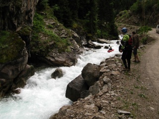
Beginning of the first rapid.
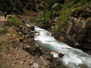
First rapid


Afterwards slightly easier, class 4-4+, sometimes even class 3-2, but afterwards with class 4 rapids. River flows through many small gorges. Warning: trees (we had 2 portages due to trees). River is quite small, fast flowing, quite steep. Before the take out tghere is a difficult drop with huge towback (one can portage or take out before it).
Upper
- Put-in: at the take out of the Upper Upper Barhal, in Barhal village, on the left bank of the river.
- Take-out:
- Length:
- Time:
- Gradient:
- Difficulty: WW 3+-4+ (4-5, 5, X)
- Last update: 2012 r.
This section is more interesting than the upper one. At the beginning slightly easier, but with a few class 5 rapids. First one - small gorge with a siphon at the beginning. One can portage a siphon and put-in the the gorge (if there are eddies) or portage the whole gorge. Next class 5 rapid - a boulder garden (boulders just below the surface) and an undercut. Afterwards a few rapids 4+, big boulders.
At the end of this part there is a drop (1.5 m) with a towback.
Afterwards difficulties are regular, class 3+-4+, all the time quite steep, sometimes a bit easier or a bit harder. Most of the time sounting not necessary (eddy hopping essential though). If it's your first run, you can do a lower section as well.
Lower
- Put-in: at the end of the upper section
- Take-out: on the right bank of the river, in Yusufeli town, close to the Greepeace (Greenpiece) campsite
- Length:
- Time:
- Gradient:
- Difficulty: WW 2-3 (3+)
- Last update: 2012 r.
Easy section, runnable als by rafts. A few rapids up to class 3.
Gauge
GPS coordinates
Map
| To jest tylko zalążek artykułu. Jeśli potrafisz, rozbuduj go. |
| W tym artykule brakuje zdjęć. Jeśli posiadasz odpowiednie, dodaj je. |
| Ten artykuł należałoby zilustrować krótkim filmem. Jeśli posiadasz taki, dodaj go. |
| W tym opisie brakuje współrzędnych GPS. Jeśli je posiadasz, dodaj sekcję Współrzędne GPS |