Adjara/en
Z BystrzeWiki
(Różnice między wersjami)
(Utworzył nową stronę „{{Languages|Adjara}} {{Rzeka | nazwa=Adjara | kraj=Gruzja | trudność= | rejon= | ujscie= }} {{Wokolicy | * Adjara/en * Mtkvari/en * Paravani/en }} == Ri...”) |
m (→GPS coordinates) |
||
| Linia 55: | Linia 55: | ||
== Water level == | == Water level == | ||
== GPS coordinates == | == GPS coordinates == | ||
| + | * {{gpsentry|Adjara Purtion Bridge put-in|41.621498°N|42.2635°E}} | ||
| + | * {{gpsentry|Adjara take-out|41.627403°N|42.172397°E}} | ||
| + | |||
== Map == | == Map == | ||
{{Mapa}} | {{Mapa}} | ||
Aktualna wersja na dzień 08:14, 22 paź 2012
| Rzeki w okolicy |
|
Spis treści |
River sections
Upper
- Put-in:
- Take-out:
- Length: xx km
- Time: hh:mm h
- Gradient: xxx ‰
- Difficulty:
- Last update: r.
brak opisu odcinka
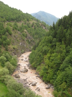
Hard section with some gorges?
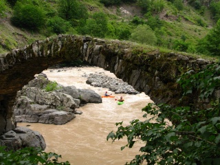
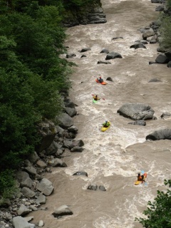
Purtion Bridge-...
- Put-in: on the right bank of the river, above the historical Purtion Bridge
- Take-out: on the road bridge a few km below. In general you can take out everywhere where river is close to the road
- Length:
- Time:
- Gradient:
- Difficulty: 2 (3) (LW)
- Last update: 2012 r.
We had low water in 2012, so it was a very easy sections. However it looked like it should be more interesting with more water. In the baginning river goes through a gorge, afterwards the gorge opens up.
Purtion Bridge - start

Adjara (LW)
Adjara (LW)


Water level
GPS coordinates
Map
External links
| To jest tylko zalążek artykułu. Jeśli potrafisz, rozbuduj go. |
| W tym artykule brakuje zdjęć. Jeśli posiadasz odpowiednie, dodaj je. |
| Ten artykuł należałoby zilustrować krótkim filmem. Jeśli posiadasz taki, dodaj go. |
| W tym opisie brakuje współrzędnych GPS. Jeśli je posiadasz, dodaj sekcję Współrzędne GPS |